The village fell to the 27th (City of Winnipeg) Battalion, part of the 5th Canadian Infantry Brigade. Reaching it fulfilled an immediate military objective. It did not deliver the breakthrough to the Belgian coast that had helped justify the offensive in the first place. That gap between the achievement of the infantry and the outcome of the campaign remains central to Passchendaele’s history.
The ambitions of July
British commander Sir Douglas Haig wanted to keep pressure on the German army after the failure of the French spring offensive. He also hoped to gain the ridges around Ypres and advance toward the coast, where German submarine facilities threatened Allied shipping. The offensive opened on July 31.
The ground limited what those plans could achieve. This was low country dependent on drainage. Shellfire broke up ditches and canals; rain accumulated in trenches and shell holes. Attacking troops had to cross exposed stretches slowly, while German forces used concrete strongpoints and machine guns to resist them. Supply and evacuation became punishing jobs even when no major attack was under way.
The struggle drew in British, Australian and New Zealand formations before the Canadians undertook its final stages. New Zealand troops suffered devastating losses on October 12. They were relieved by Canadians later that month. There was no fresh battlefield waiting for the newcomers, only an exhausted one.
Preparing another advance
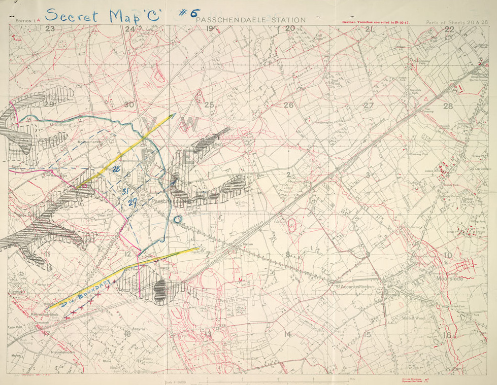
Canadian Corps commander Arthur Currie objected to committing his men in these conditions, but the decision stood. Preparation had to make a limited advance possible: routes, guns, ammunition and the movements of infantry all needed attention. An October planning map preserved by Library and Archives Canada records revised boundaries and objectives for the 6th Canadian Infantry Brigade. Its neat lines describe a landscape that was anything but orderly underfoot.
The Canadians attacked on October 26 and again on October 30. During the second assault, the 4th Canadian Division took Crest Farm, a strongly defended position overlooking the approaches. The advance brought the attacking force to the edge of Passchendaele. The November 6 assault then secured the village itself. Fighting continued, with a further Canadian attack on November 10 clearing the eastern edge of the ridge.
Holding ground that swallowed roads
The surviving photographs show why taking a position was only part of the task. Canadian pioneers laid out routes through mud and carried wooden trench mats toward the front. Men of the 16th Canadian Machine Gun Company held positions in shell holes. In another view, German prisoners helped move wounded Canadians while men carrying track material traveled in the opposite direction. The same narrow routes had to support both movement forward and evacuation backward.
These scenes give physical meaning to the campaign’s casualty figures. Veterans Affairs Canada records more than 4,000 Canadian dead and nearly 12,000 wounded at Passchendaele. That total belongs to the Canadian fighting there, not to the single day on which the village was captured.
The Canadian memorial stands at Crest Farm, looking over a landscape rebuilt after the war. Its location recalls the hard-won tactical advances. The coast remained beyond the army’s reach. Both facts belong in the account: soldiers accomplished what they had been ordered to do, at an immense price, inside an offensive whose larger promise went unfulfilled.
Cover image: Library and Archives Canada, PA-002162; MIKAN 3233069